AO-surface-water

Using evidence

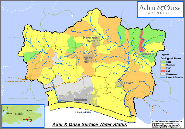
Evidence is a core part of integrated catchment management. Without it, we cannot make informed, fair and justifiable decisions on what the best courses of action and monetary investments are.  Evidence ranges from scientific monitoring data and academic research, to best practice techniques and local knowledge. Combining and scrutinising as wide an evidence base as … Continued

Sussex Coast issues

The quality of coastal and estuarine waters is fundamental to the economic and social value of fisheries and tourism, as well as marine habitats and wildlife. However the same geographic area needs to accommodate the development needs of harbour transport, commercial fishing activities and local communities. The Sussex coastline and its estuaries are designated as … Continued

Sussex Coast description

The coastline and the sea have always been at the heart of the attraction of Sussex. Not only do they provide a haven for the many and varied wildlife, coastal waters are highly valued for transport, fisheries and tourism. The estuaries of the rivers Adur and Ouse, which open to the sea at Shoreham and … Continued

RIver Ouse costs and benefits

When designing a project, such as those displayed in our project maps, it is usual to carry out a Cost Benefit Analysis.  This is an exercise that weighs up the predicted costs of the project against the financial benefits that undertaking the project will bring.  It is usually expressed as a ratio of costs:benefits and benefits … Continued

River Ouse issues

The water quality of the river Ouse is compromised by a range of pressures, from isolated sources of pollution through to the combined effects of multiple diffuse sources, both rural and urban.  Evidence driving the ecological status of the river system shows that nutrification, particularly phosphates in freshwaters, are a primary reasons for poor water quality. Other … Continued

River Ouse description

The river Ouse runs north to south down the eastern side of the catchment. The feeder streams of the Ouse are small and shallow forest streams, which become flashy in times of heavy rainfall. Some of the middle Ouse tributaries are similar, whilst others are characteristic of slow-flowing lowland streams, attributable in places to historic … Continued

River Adur costs and benefits

When designing a project, such as those displayed in our project maps, it is usual to carry out a Cost Benefit Analysis.  This is an exercise that weighs up the predicted costs of the project against the financial benefits that undertaking the project will bring.  It is usually expressed as a ratio of costs:benefits and benefits … Continued

River Adur issues

The water quality of the river Adur is compromised by a range of pressures, from isolated sources of pollution through to the combined effects of multiple diffuse sources, both rural and urban. Evidence driving the ecological status of the river system shows that nutrification, particularly phosphates in freshwaters, are a primary reasons for poor water quality. Other … Continued

River Adur description

The river Adur runs north to south down the western side of the catchment. The main river is fed by two arms, the Adur East and the Adur West, both fed by many tributaries and ditches. The arms meet just west of Henfield, where the river becomes tidal and embanked for some nine miles before it reaches … Continued

Brighton Chalk Block issues

Under the Water Framework Directive, aquifers are classified according to their quality and quantity. The quality of groundwater is assessed by chemical tests, and the quantity of groundwater considers the impact that abstraction has on the amount of water left in the environment. Whichever is the poorest assessment (i.e. quality or quantity) dictates the overall … Continued

Sign up for your newsletter


Keep up to date with the latest developments.